How HIGBs Could Redraw Oahu's Housing Map
Listen to this article:
The real story is not the bond bill. It is the map.
Housing Infrastructure Growth Bonds, or HIGBs, sound like a technical public-finance tool. In reality, the more important question for O'ahu real estate is much simpler: which neighborhoods become actually buildable if infrastructure can be paid for earlier?
That distinction matters. O'ahu already has many areas where policy supports more housing. The island does not have enough places where housing is both entitled and financeable on a realistic timeline. Roads, sewer upgrades, drainage, utility relocation, flood work, complete streets improvements, and station-area connectivity often have to happen before vertical development can proceed at scale. When those costs hit too early, projects stall, land sits underused, and "planned growth" stays on paper.
The 2026 constitutional proposal describes HIGBs as bonds repaid only from the incremental increase in real property tax revenues within a designated district, essentially a tax-increment model without raising tax rates. The Legislature's own findings say Hawai'i needs additional value-capture tools because ordinary county and state funding is not enough, and because counties need options that do not crowd out traditional bonding capacity.
For buyers, sellers, and landowners, the implication is significant: the next appreciation story may not be where density is allowed, but where infrastructure timing finally lines up with redevelopment. In my view, that shifts attention away from legislative mechanics and toward specific submarkets where hidden land value could be unlocked first.
Why infrastructure timing matters more than zoning on O'ahu
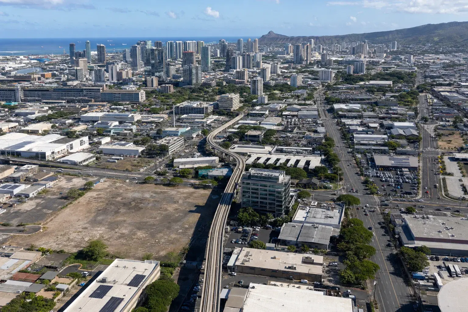
O'ahu has spent years planning for transit-oriented development, especially along the rail corridor from Kalihi through Downtown, Civic Center, Kaka'ako, and Ala Moana. The state's station-area maps identify 21 stations and half-mile catchment areas. But planning maps do not write checks, and that has been the persistent problem.
The state's TOD Infrastructure Financing and Delivery Strategy study is unusually direct on this point. It concludes that additional value-capture tools are needed to supplement county and state resources, and the O'ahu implementation summary notes that TIF-style financing is viable but constrained by district economics. In Iwilei specifically, the study says financing capacity should inform the timing of infrastructure requirements. That is a crucial line for anyone trying to understand where housing can really move next.
Districts dominated by affordable rental housing may generate less tax increment because many projects receive real property tax exemptions. By contrast, districts with a stronger mix of market-rate residential, hotel, retail, commercial, and industrial value can create tax increment faster. Honolulu's FY 2025-2026 tax structure underscores that point: residential property is taxed far below hotel, resort, and commercial uses. That means mixed-use urban districts can potentially support infrastructure financing more readily than purely affordable ones.
The practical takeaway is not that HIGBs solve every housing problem. It is that they could change project sequencing. If a district can front-fund sewer, drainage, roads, and utility work, private development no longer has to carry all of that uncertainty lot by lot. That is when land begins to reprice.
Iwilei and Kalihi look like the most underappreciated beneficiaries
If one part of urban Honolulu appears most likely to gain from this tool, it is Iwilei-Kapalama, with Kalihi close behind. The Iwilei infrastructure planning area alone spans about 555 acres and has long been envisioned as a high-intensity mixed-use district tied to rail. The city is already assembling land there and nearby, including the 3.8-acre Iwilei Center property and the 0.8-acre 445 N. King site in Kalihi, where the city has identified potential for roughly 750 to 1,000 units.
What makes this geography especially interesting is that it already has many ingredients for redevelopment: central location, proximity to job centers, station-area planning, underutilized commercial and industrial parcels, and large enough blocks to matter. What it lacks is smooth delivery of off-site infrastructure at the right moment. That is exactly where HIGBs could matter most.
A district-level financing mechanism could help front-fund street grid upgrades, drainage improvements, sewer capacity, utility relocation, multimodal streets, and public-realm work that no single parcel can easily absorb on its own. For smaller or fragmented sites, that could be the difference between "good long-term land" and "financeable now."
I would be careful not to oversell it. Iwilei is still difficult. The state's own TOD report warns that affordable-housing-heavy buildout may weaken tax increment. Historic context, adjacency to Chinatown, and unresolved urban-core rail timing also matter. Still, if you are looking for the place where HIGBs could unlock the biggest change in perceived land value, Iwilei and the broader Kalihi corridor are the clearest candidates.
Aloha Stadium may be the cleanest test case, while Kaka'ako and Ala Moana are different stories
Not every district would benefit from HIGBs in the same way. Aloha Stadium/Halawa stands out because it is the clearest example of a large redevelopment zone where infrastructure must arrive first. Reporting in 2025 indicated that the selected developer saw roughly a $200 million financial gap and sought a TIF-style subsidy, with Stanford Carr calling the approach "very essential" because infrastructure has to be built ahead of the district itself. That is textbook district-financing logic: large land area, major utility and road needs, low current tax base, and substantial future assessed-value upside.
Kaka'ako is a different case. It is already proven as a condo and mixed-use district. HIGBs would not so much make Kaka'ako possible as potentially accelerate edge improvements, mixed-income projects, or connector infrastructure. In other words, Kaka'ako is more about timing and extension than newly discovered feasibility.
Ala Moana has enormous tax-generating potential and deep condo market acceptance, but it remains heavily tied to the deferred rail extension. As long as the final urban-core segment remains unresolved, Ala Moana is harder to classify as an immediate HIGB winner, even if it is highly financeable in theory.
Waikiki belongs in the conversation only selectively. The city's acquisitions at Waikiki Vista and 1615 Ala Wai suggest targeted affordable-housing potential, and edge-Waikiki could benefit from drainage, streetscape, and connectivity improvements. But parcel fragmentation, flood exposure, and political complexity make it more of a surgical infill story than a district-transformation story.
What this could mean for condo buyers, sellers, and investors
For condo buyers, the main benefit of HIGBs would be more location choice. O'ahu's condo market remains affordability-sensitive. In April 2026, the median resale condo price was $500,000, sales were down 4.3% year over year, and active inventory was down 6.3%. Honolulu Board of REALTORS® President Aaron Tangonan noted that mortgage rates, condo insurance, and overall affordability are shaping buyer behavior. In that environment, newly financeable station-area neighborhoods could eventually create alternatives to the usual Kaka'ako, Ward, and Ala Moana concentration.
Still, buyers should not assume this tool automatically lowers prices. Often, infrastructure certainty is first capitalized into higher land values. In stronger districts, some of the benefit may go to landowners and developers before it reaches end users. That is why timing matters. Early buyers into improving neighborhoods may benefit from broader neighborhood uplift, while later buyers may face fully repriced land and product.
For sellers and landowners, this is where the hidden-value story becomes more concrete. Parcels near stations or connectors in Kalihi and Iwilei, especially older commercial or industrial sites, may gain optionality before any tower is announced. A mediocre parcel inside a funded infrastructure district can outperform a better-looking parcel outside one.
For investors, I think the most attractive strategy is buying timing rather than glamour. Kaka'ako is already understood. The more interesting bet is where the market has not fully priced in district-level infrastructure support yet. On current evidence, that means keeping a close eye on Iwilei, Kalihi, and Halawa.
The biggest risks: revenue limits, rail delays, and overestimating how fast change arrives
There are several reasons to stay realistic. First, TIF-style tools work best where taxable assessed value grows quickly. The state's O'ahu TOD summary explicitly notes that affordable rental-heavy districts may produce weaker increment because of tax exemptions. That creates an uncomfortable tension: the places with the greatest housing need are not always the places with the strongest bond repayment profile.
Second, counties may reasonably worry about diverting future property tax growth away from general services. The same O'ahu implementation discussions flagged concerns about fiscal flexibility and noted that traditional general obligation bonds remain cheaper where they can be used. HIGBs are not free money; they are a bet that future district growth will be strong enough and predictable enough to support debt today.
Third, rail completion still matters. A district can be mapped for TOD and still remain slow to absorb new housing if the transit system itself is incomplete. That risk is most obvious from Civic Center toward Kaka'ako and Ala Moana, where the final segment remains postponed under the current recovery framework.
Finally, even a newly financeable district may not become immediately buildable if the condo market softens, construction costs stay elevated, or lenders remain selective. HIGBs can improve feasibility, but they do not repeal market discipline.
The best way to read this policy idea is not as a guarantee of a building boom. It is a framework that could turn planned but stranded land into phased, financeable land. On O'ahu, that would be a major shift. And if that shift comes, I expect the map to change first in Iwilei-Kalihi, not just in the already-celebrated core.
- For station-area maps, readers can review the state TOD maps at the Hawai'i Office of Planning and Sustainable Development.
- For rail status, HART's official project and route maps remain the most reliable public source.
- For flood and hazard verification on any specific parcel, buyers should check FEMA Map Service Center, the City and County of Honolulu GIS resources, and other official public databases directly.
- Building and district information online is useful, but it should always be personally verified before making purchase or investment decisions.
Sources: Based on the 2026 Hawaiʻi HIGB constitutional proposal, the state TOD Infrastructure Financing and Delivery Strategy study, Oʻahu TOD implementation materials, City and County of Honolulu housing and bond documents, HART station and project status maps, Honolulu Board of REALTORS® market statistics, and reporting on Aloha Stadium redevelopment.
Disclaimer: This article is provided for general informational purposes only and does not constitute legal, financial, or real estate advice. Market conditions change frequently; readers should conduct their own due diligence and consult qualified professionals before making decisions.